Seven plaques, seven destinations. This is the full Brant to the Battlefield loop, and every stop on it is worth the detour on its own. Three of them come with full local guides below — where to eat, where to browse, and how to time your visit.
Fair warning
This page names every destination on the loop. If you haven't played the quest yet, the riddles won't stand a chance — play first, browse after.
Featured destinations
Featured stop · 1 of 7
Joseph Brant House
The house Joseph Brant built around 1800 on the shore of Burlington Bay — or the 1930s reconstruction standing where it stood. Brant was the Mohawk leader who fought beside the Crown in the American Revolution, and the town that grew up around him was first called Wellington Square. The museum grounds hold the whole story.
Tribeca Coffee Co.Alia's Gelato & CaféSpencer's at the WaterfrontPure Boutique
In August 1813, two American warships capsized in a Lake Ontario squall and sank with more than 50 sailors aboard. Their wrecks, found in 1973 about 90 metres down, are among the best-preserved War of 1812 sites anywhere. The plaque stands in Confederation Park, steps from the beach.
Hutch's on the BeachBaranga's on the BeachHamilton Antique Mall
On the night of June 5, 1813, 700 British regulars marched out of Burlington Heights and smashed an American camp of 3,000 — capturing both enemy generals before dawn and turning the 1813 invasion around. The 32-acre park holds the Gage farmhouse, a 100-foot monument, and the re-enactment every June.
The house Joseph Brant built around 1800 on the shore of Burlington Bay — or the 1930s reconstruction standing where it stood. Brant was the Mohawk leader who fought beside the Crown in the American Revolution, and the town that grew up around him was first called Wellington Square. The museum grounds hold the whole story.
Lakeshore Rd & North Shore Blvd E, Burlington · Plaque: The Brant House — Ontario Heritage Trust
The storyThe Man Behind the House
He was born Thayendanegea in the spring of 1743, in what is now Ohio, into the Wolf Clan of the Mohawk — and grew up to become perhaps the best-known Indigenous figure of his generation, a man who met both George Washington and George III. As interpreter, translator, war chief, and statesman, Joseph Brant moved between worlds that were trying to destroy each other, and did it mostly on his own terms.
In 1761, at eighteen, he entered Eleazar Wheelock's Moor's Indian Charity School in Connecticut — the school that would become Dartmouth College — learning to read and write English alongside the classics. During the American Revolution he allied with Britain, leading Mohawk and Loyalist volunteers on the New York frontier, and afterward helped steer the Haudenosaunee toward a new home in Upper Canada.
Around 1802 he settled on his Burlington Bay grant, and he died here — at Burlington Beach — on November 24, 1807. The house he built around 1800 stood on this spot; the present building is a 1937–38 restoration replica on the estate grounds. The man is gone and the land was sold off long ago, but his name is everywhere.
In October 1784, Governor Frederick Haldimand issued a proclamation setting aside a large tract along the Grand River — from Lake Erie to the river's head — for the Six Nations and their allies, in recognition of their service to the Crown during the Revolution. It was an enormous grant: 18th-century accounts put it at roughly two million acres, though modern Six Nations summaries use a figure closer to 950,000. The honest version is that the acreage itself has been contested for two centuries.
Brant treated the land as an asset to fund a future. He sold and leased parcels to settlers — a deliberate strategy to generate revenue and secure the Nations' position — but Crown officials questioned whether the Six Nations could legally alienate the land at all, some buyers simply never paid, and Brant faced criticism from within his own community over the deals.
The Six Nations' own court filings summarize continuing allegations about improper sales and mismanaged trust funds from those transactions. The land question is not just history here; in a very real sense, it is still open.
Behind Joseph Brant stood someone at least as formidable: his elder sister Koñwatsi'tsiaiéñni — Molly Brant. A Clan Mother and head of the Six Nations matrons, she held the kind of authority colonial officials struggled to file away: the power to raise and remove chiefs, and a voice in war and peace.
In 1759 she became the partner of Sir William Johnson, the Crown's Superintendent of Indian Affairs, and the manager of his sprawling household — which made her the most powerful Indigenous woman in colonial North America and a quiet force in British-Indigenous diplomacy. When the Revolution came, she threw herself into the Loyalist cause: rallying support, sheltering refugees, and passing along intelligence that British commanders treated as gospel.
Forced to flee New York, she rebuilt her life in Kingston, where she lived on as a respected stateswoman until her death in 1796 — eleven years before her brother died at Burlington. Burlington remembers Joseph; Kingston remembers Molly. History gave them different cities, but the family business — diplomacy at the highest level — was shared.
Here is a small irony to carry down Brant Street: the city is not named for Joseph Brant. In 1792, Lieutenant Governor John Graves Simcoe named the western end of Lake Ontario "Burlington Bay" after Bridlington, a coastal town in Yorkshire, England — and by the time Brant settled on its shores around 1802, the name was already in common use for the water. The city simply inherited the bay's name.
Brant did get a city named for him, just not this one. Brantford, on the Grand River, sits on the Haldimand Tract and is named for Joseph Brant outright — Brant's ford, the river crossing, doing the heavy lifting.
Burlington paid its respects eventually. In 1886 the Joseph Brant Memorial was erected here in his honor and that of the Six Nations Confederacy, and the town's main street still carries his name. So the geography is a little tangled: Brantford has the name, while Burlington has the house, the memorial, and the street. The chief, one suspects, would have appreciated the redundancy.
The Joseph Brant Museum from the northwest — a reconstruction on the grounds of Brant's old estate. (Dave Lauretti (flickr) via Wikimedia Commons, CC BY 2.0)Joseph Brant at 33 or 34, painted in London by George Romney in 1776. (George Romney, Public domain)
In August 1813, two American warships capsized in a Lake Ontario squall and sank with more than 50 sailors aboard. Their wrecks, found in 1973 about 90 metres down, are among the best-preserved War of 1812 sites anywhere. The plaque stands in Confederation Park, steps from the beach.
Near Edgewater Pavilion, Confederation Park, Hamilton · Plaque: Hamilton & Scourge — Ontario Heritage Trust
The storyThe Squall
The night of August 7–8, 1813. An American squadron was cruising Lake Ontario when a sudden, violent squall tore through the fleet — lightning, black water, sails still set. The Hamilton Civic Museums, which steward the site's memory, describe what happened next: in the early morning hours of August 8, the Hamilton and the Scourge "foundered during a storm on Lake Ontario off Port Dalhousie," capsizing "in a matter of moments." The death toll was at least 53 crewmen — "the largest loss of United States naval personnel in a single event during the War of 1812." Canadian Geographic puts it more plainly: 53 sailors taken "to their watery graves" in the lake's "cold, dark waters." They were merchant hulls pressed into naval service, carrying more gun than they'd been built for — in the dark, with no time to shorten sail. Not a battle, not an enemy broadside: weather. The largest single loss the U.S. Navy suffered in the entire war, and it wasn't inflicted by anyone.
Neither ship was born a warship. The Hamilton began life as the Diana, an American merchant schooner; the Scourge as the Lord Nelson, a Canadian merchant topsail schooner. They were, in the Civic Museums' words, "simple merchant ships that were pressed into service for the American Navy" — the Scourge illegally seized by the Americans before the war even started. As warships they were improvisations, and it showed. The Hamilton carried eight 12-pounder carronades plus a big pivot-mounted "Long Tom" — a 24- or 32-pounder amidships — with a crew of fifty. The Scourge mounted eight smaller guns, four 6-pounders and four 4-pounders, also with fifty men. Both did real service: each played a role in the American capture of Fort George in May 1813. They were workhorses — warships the way a minivan with a roof rack is an expedition vehicle. Sturdy enough until the weather asked more of them than they'd been built for.
The men who died that night are mostly nameless now — but one of them talked. Ned Myers, a sailor on the Scourge, survived the sinking and years later told the whole story to James Fenimore Cooper — yes, the Last of the Mohicans novelist — who published it as a biography, A Life Before the Mast. The Civic Museums preserve Myers' own words about the last minutes: "The flashes of lightning were incessant, and nearly blinded me. Our decks seemed on fire, and yet I could see nothing. I heard no hail, no order, no call; but the schooner was filled with the shrieks and cries of the men..." Fifty-three sailors went down with the two ships. Every August, Hamilton holds a sunset ceremony at the Naval Memorial Garden in Confederation Park — right near this plaque — to mark the loss. Members of the American Legion in Canada tend the markers, placing a new star-spangled banner on each one. Two centuries on, the flags still go up every year.
The wrecks waited 160 years. In 1973 Daniel Nelson — a dentist from St. Catharines — found both hulls; they lie upright, sources wobbling between 88 and 90 metres down, roughly 500 metres apart. And they are astonishing: masts still standing, cannons visible on deck, the cold dark water holding everything in place. The lake is a time capsule — little light, little oxygen, barely above freezing. The finds drew the greats: Jacques Cousteau filmed them in 1980, National Geographic's Emory Kristof in 1982, Titanic-finder Robert Ballard in 1990. In 1976 the site was designated a National Historic Site of Canada, as rare surviving examples of merchant ships converted to warships. Today the City of Hamilton owns and manages them. You can't dive them, and you can't see them from the plaque — but stand at Confederation Park, look out over the water, and you're looking at the roof of a perfectly preserved 1813 world.
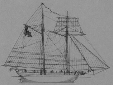
The sail plan of USS Hamilton — born the merchant schooner Diana — lost August 8, 1813. (U.S. Navy (via Wikimedia Commons), Public domain)Her sister ship: the sail plan of USS Scourge — born the Lord Nelson — lost the same night. (U.S. Navy (via Wikimedia Commons), Public domain)Confederation Park's waterfront. The Hamilton & Scourge plaque stands near the Edgewater Pavilion. (Jeff Hitchcock, CC BY 2.0)
On the night of June 5, 1813, 700 British regulars marched out of Burlington Heights and smashed an American camp of 3,000 — capturing both enemy generals before dawn and turning the 1813 invasion around. The 32-acre park holds the Gage farmhouse, a 100-foot monument, and the re-enactment every June.
Battlefield Park, 77 King St W, Stoney Creek · Plaque: Battle of Stoney Creek 1813 — Ontario Heritage Trust
The storyThe Midnight Bayonet Charge
After Fort George fell in late May 1813, about 3,500 American troops chased the retreating British west along Lake Ontario and camped for the night at the Gage family homestead in Stoney Creek. They were confident — the British were supposed to be finished. Lt.-Col. John Harvey disagreed. He had personally scouted the American camp, and around 11:30 p.m. on June 5 he marched out of Burlington Heights with just 700 regulars of the 8th and 49th Regiments of Foot. They reached the sleeping camp around 2 a.m. on June 6 — bayonets fixed, in near-total darkness — and what followed was chaos: both sides firing at muzzle flashes, shouted orders swallowed by the dark. The 49th's bayonet charge overran the American artillery on the knoll and captured two generals before dawn. The attack broke the American offensive: the invaders fell back to Forty Mile Creek and then to Fort George, and the British re-established their position on the Niagara frontier. Exactly how it unfolded in the dark is still debated — night actions always are — but the outcome isn't: 3,500 men advanced, 700 stopped them, and the 1813 invasion of Upper Canada ended right here.
Two of the strangest prisoners of the War of 1812 were taken on a dark hillside in Stoney Creek. Brigadier-Generals William H. Winder and John Chandler were commanding the American camp when Harvey's attack hit — and in the pitch-dark confusion, both men wandered straight into the British line, apparently believing it was their own. They were captured before dawn on June 6. Winder, a Maryland lawyer commissioned in 1812, was held until a prisoner exchange freed him in 1814. His war wasn't over: he was given command of the Tenth Military District, and on August 24, 1814, he led the American forces at Bladensburg, Maryland — the disastrous defeat that opened the road to Washington and the burning of its public buildings. He was court-martialled afterwards and acquitted, dying in Baltimore in 1824. Chandler, a Revolutionary War veteran from Massachusetts, was likewise exchanged in 1814 — and traded the battlefield for the statehouse. He became the first president of the Maine Senate, then a U.S. senator from 1820 to 1829, before resigning to become Portland's customs collector. A Revolutionary, a prisoner, a senator — all because he walked the wrong way in the dark.
Battlefield House wasn't built for history — it was built by a widow starting over. Mary Jones Gage came up from New York State in 1789 with her children James and Elizabeth, after her husband was killed in the Revolutionary War. The frame house went up in 1796, grew to two storeys around 1830, and the farm became one of the most valuable in Saltfleet Township. Then, in 1813, the battle happened around it. By 1899 the old house was in danger of being forgotten — until Sara Calder, a Gage descendant, broke away from the Wentworth Historical Society, formed the Women's Wentworth Historical Society, and bought the house and four and a half acres by public subscription. It opened as a public park on October 21, 1899. Then came the bigger project: a 100-foot monument on the hill south of the house — the first sod turned by Lady Grey in 1908, the cornerstone laid by General Sir John French in 1909, and the unveiling on June 6, 1913, by Queen Mary pressing a button in Buckingham Palace. One correction worth making: the Gage house didn't serve as the field hospital. A Hamilton Historical Board marker identifies a 1794 frame building beside the neighbouring Nash-Jackson house — moved to Battlefield Park in 1999 — as the actual hospital, demolished in 1910.
Did the Battle of Stoney Creek save Upper Canada? The official plaque on this site is carefully worded: Harvey's night attack 'halted the American advance and allowed the British to re-establish their position on the Niagara frontier.' A real, limited claim — and a true one. The Americans never advanced that far into the Niagara Peninsula again. Tourism Hamilton goes considerably bigger: the British victory 'was crucial in preventing the Americans from seizing Upper Canada,' and the battle was 'the turning point of the War of 1812.' So which is it? Most likely somewhere in between. Stoney Creek did break the American offensive of 1813 — a 3,500-strong invasion force ended the campaign in retreat. But 'turning point of the whole war' is the kind of thing a town understandably puts on its festival posters. The cautious version is probably the truer one: one decisive night that ended one invasion. The grand claims came later, from the people who needed heroes.
The 100-foot Battlefield Monument, on the hill south of the Gage homestead. (Magnolia677, CC BY 4.0)Battlefield House, the Gage family homestead. Begun 1796. (Nhl4hamilton, Public domain)The battle plaque at the monument's base. (Dan Luisetto, CC BY-SA 4.0)
Joseph Brant's 1798 grant. James Gage bought land 1810, laid out town site. First called Wellington Square. Post office 1826. Tannery, pottery, steam grist-mill by 1846. Great Western Railway 1854. Village of Burlington 1873, town 1914. Nearby: Tamp Coffee Co..
Brant St & Ontario St, Burlington · Plaque: The Founding of Burlington — Archives of Ontario
René-Robert Cavelier, Sieur de La Salle, landed near this spot September 1669 — believed first white man on these shores. Stone marker erected 1928. ~120 m walk southwest from the parking lot. Nearby: Peach Coffee Co..
La Salle Park, Aldershot (839-841 Lasalle Park Rd), Burlington · Plaque: Sieur de La Salle marker — Wentworth Historical Society, 1928
Burial knoll where American guns stood. 20 King's men buried here. Inscription revised and stone re-dedicated June 6 1956 by HM Army & Navy Veterans Society of Hamilton. Nearby: The Powerhouse.
70 King St W, Stoney Creek (across King St, slightly east of Battlefield Park) · Plaque: The Battlefield of Stoney Creek — re-dedicated 1956
19th-century farmhouse. Inspired by Adelaide Hoodless, supported by husband Erland, Janet Lee drafted the constitution of the Stoney Creek Women's Institute here in 1897. Movement spread across Canada and the world. Nearby: The Innsville.
552 Ridge Rd (just west of Dewitt Rd), Stoney Creek · Plaque: The Erland Lee Home and the First Women's Institute / First Women's Institute 1897